Today in Art Year 4 created Geometric mosaics. They carefully coloured their mosaic squares using squared paper and cut them out ready to begin placing them on their mosaic template.
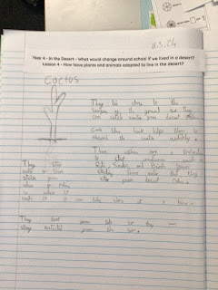
This week, the children recapped their previous knowledge of the continents and oceans. They then debated the words: habitat and adaptation. Some very interesting ideas. From there they researched how (using real cacti) cacti are able to live in the desert through their use of long roots system so they can gather up as much water as possible as it does not rain much in a desert. Furthermore, they have spikes on them instead of leaves to protect them from being eaten and animals sucking out its water. Following on, the children looked at how a camel is able to live in the harsh conditions of a desert. Did you know that they have two sets of eyelashes? They can close their nostrils and their fur protects them from the sun as well as keeping them warm at night.
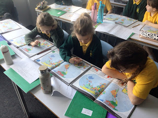
This week, the children have been using atlases to identify where Europe is in the world and the countries which are found there. This is what the children identified. Europe is a continent that we live in and it is one of the smaller continents. Parts of Turkey and Russia can be found in both Europe and Asia? Some of the countries in Europe are land locked. The largest country is Russia and the smallest country is Vatican City. Italy is shaped like a boot. Lots of people live in Europe. Europe is in the Northern Hemisphere. Well done year 4 some amazing conversations and observations.


Comments
Post a Comment