Posts

Showing posts from November, 2023

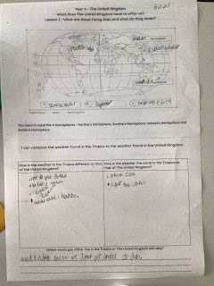
Which region do we live in?

Image
 This week’s lesson had the children identifying what a region is and what region do they live in as well as  locating some of the famous cities in The United Kingdom.  The children were told that a region is like an area in their playground. There are areas for sand, mud, building and cycling. The United Kingdom is split into areas so it is easier to find out data and information about that area (administrative). Using their compass points they identified each region and hopefully they will remember that they live in the South East region. Then, they recapped the capital cities of the four countries making up the United Kingdom as well as identifying different cities ( we used our knowledge of sports teams and holidays to help us). 

What is Europe?

Image
 This week, the children have been using atlases to identify where Europe is in the world and the countries which are found there. This is what the children identified.  Europe is a continent that we live in and it is one of the smaller continents.  Parts of Turkey and Russia can be found in both Europe and Asia?  Some of the countries in Europe are land locked. The largest country is Russia and the smallest country is Vatican City. Italy is shaped like a boot.  Lots of people live in Europe. Europe is in the Northern Hemisphere.  Well done year 4 some amazing conversations and observations. 

The United Kingdom

Image
Welcome to year 4 Geography. This term the children will be studying The United Kingdom. Here is their journey and their new vocabulary mat for the term.  During the first lesson the children looked at how the Equator splits the Earth into two hemispheres: Northern and Southern Hemispheres. In the lesson today, they were introduced to the Prime Meridian (vertical lines of longitude) which splits the Earth into two other hemispheres: Eastern and Western Hemispheres.  They were also introduced to two lines of latitude, Tropic of Capricorn and the Tropic of Cancer. The two lines of latitude are north and south of the Equator and the Tropics can be located  between these two lines. Once the children identified these lines, they then compared the climate of the tropics to that of the United Kingdom.